
SERVICES OFFERED
EXTERIOR REAL ESTATE PHOTOGRAPHY
Exterior
Taking impressionable photos of a house just got way easier! Our FAA licensed pilot can get the job done at an attractive price. Whether it’s to document construction of your dream home, begin planning a project, or make a remarkable real estate listing, First in Flight can provide the services you require. Photos by default will be edited and in JPEG format for web publishing. We giveh the option to add a realistic blue sky in the background for the cloudiest of Rochester days! RAW stills and stabilized 4k video footage are no problem for us! Pricing starts at just $150 for up to 10 edited exterior photos.

.jpg)

COMING SOON! - INTERIOR REAL ESTATE PHOTOGRAPHY
Ready. Steady. Click.
Coming soon! Interior real estate photography pictures. Pricing / packages TBD.

Stock Footage of a living room
Stock Footage of a living room
COMMERCIAL PHOTOGRAPHY
Real Estate, Inspections, Insurance, and more
First in Flight has experience in showcasing the best views for your commercial property. Whether it's a real estate listing, property inspection or insurance related, they all need to be done! These shots aren't limited to sky high either. Sometimes a ground level shot from 10' in the air can tell a better story.


CONSTRUCTION PROJECT PROGRESS
Photo & Video Capture, Video Editing
Construction progress photos & videos are useful for documentation, marketing, and claim management. Proof of progress is a thing of the past! We are available to take progress photos at regular intervals or an as-needed basis. Photos can be taken from the exact same location. Pricing varies depending on size & location of the project, as well as frequency. Contact us to discuss your needs and get a quote.

2-1-20

2-8-20

3-14-20
2-1-20
ORTHOMOSAIC MAPS
Better than Google satellite view!
Through a process called photogrammetry, we can create orthorectified maps(fancy term for removing the perspective of the camera) that are typically accurate within 1-2 feet*. We can create these maps of pretty much any location, large or small. Each scenario is unique, requiring a certain level of detail & number of photos. IE, a parking map won't require the same relative accuracy as a construction progress map. Pricing starts at $300, and depends on area to be mapped, quality required, additional editing, distance from Rochester, and more.
Example uses include:
Events:
Weddings
Parking Assignments
Sports Complex
Urban Planning
Land Management & Development
Construction Progress
Use maps to plan the job such as laydown yard, clearing limits, haul routes, and site access.
Verify existing conditions. Typically these maps can be imported into CAD software and scaled based on known points. While this method does not give 100% absolute accuracy, they are relatively accurate (IE 10ft on the ground is still 10ft on the map) these maps will be close enough to know if there is a change in condition.
Plan upcoming work based on work completed to date.
Track progress & watch a job grow. Compare to previous maps to establish a timeline.
Avoid claims & quantity disputes.
*Disclaimer: First in Flight is not a PLLC nor do we employ a PLS. Our map & 3D deliverables are intended for relative reference only and shall not be used for legal drawings, engineering drawings or any other official use. First in Flight waives all liability for use beyond what is intended.

Construction Laydown Yard
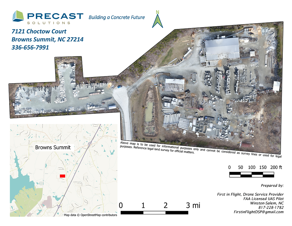
Flyer with Map for Concrete Precaster
Construction Laydown Yard